Würzjoch: Dolomites pass for hiking and panoramic drives
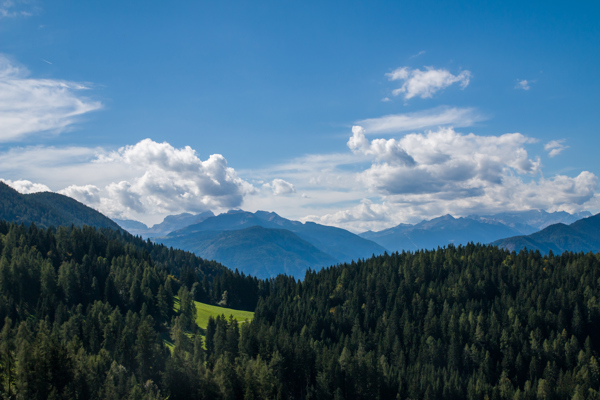
The Würzjoch pass (Ladin: Ju de Börz, Italian: Passo delle Erbe) lies at an altitude of around 2,000 metres above sea level. It connects the Eisacktal valley with the Gadertal valley and forms the northern border of the Puez-Geisler Nature Park. Surrounded by wide alpine meadows, rugged rock faces and the imposing Peitlerkofel, the Würzjoch is a popular starting point for hikes, mountain tours and scenic drives.
Interesting facts about the Würzjoch
- Altitude: 1,982 m above sea level
- Location: between the Eisacktal valley/Lüsen and the Gadertal valley/Untermoi
- Access: via the SP30 (Lüsen) and SP20 (Afers/Villnöss or St. Martin in Thurn/Untermoi) roads
- Number of hairpin bends: approx. 40 hairpin bends on the route between Brixen/Afers and St. Martin in Thurn
- Gradient: depending on the route taken, 5-7.5% on average and approx. 15% maximum gradient
- Winter closure: in winter, only accessible from the west via the Gadertal valley
- Best time to visit: June to September (all outdoor activities possible, hiking trails and huts open)

The mountain tour to the Peitlerkofel (or around the striking Dolomite mountain) starts at the Würzjoch Pass
Unsplash / David BeckerLandscape, location & special features
The Würzjoch pass is a natural link between the Eisacktal valley in the west and the Gadertal valley in the east – and thus also the border between German- and Ladin-speaking South Tyrol. Surrounded by the gentle alpine pastures of Lüsen in the north and the striking rocky peaks of the Dolomites in the south, the pass offers an impressive panorama.
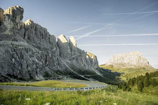
Popular photo motif: Peitlerkofel
Particularly striking is its proximity to the Peitlerkofel (2,875 m) – a freestanding Dolomite peak that rises south of the Würzjoch and dominates the landscape. Its striking shape makes it a popular photo motif (and mountaineering destination). The pass is also located on the edge of the Puez-Geisler Nature Park, an area of particular geological and botanical importance.
Hiking & mountain tours around the Würzjoch

The first rays of sunshine in the Dolomite mountains near St. Martin in Thurn
Internet ConsultingThe Würzjoch is an ideal starting point for hikes and mountain tours in the Dolomites, mainly because of its easy accessibility, magnificent views and proximity to the Peitlerkofel. Both leisure hikers and ambitious mountaineers will find suitable routes here.
Hiking tips starting at the Würzjoch
- Roda de Pütia: moderately difficult hike around the Peitlerkofel | approx. 4-5 hours, 640 metres of elevation gain
- Peitlerkofel: scenically impressive summit tour with a short climb to the main summit | approx. 5 hours, 950 metres of elevation gain
- Maurerberg hut: leisurely hike with magnificent views | approx. 3-4 hours, 470 metres of elevation gain
Many routes can be combined, so that short walks are just as possible as extended day trips – always accompanied by the impressive backdrop of the Dolomites.

Ambitious bikers can also reach the Würzjoch Pass under their own power or discover the surrounding area on two wheels.
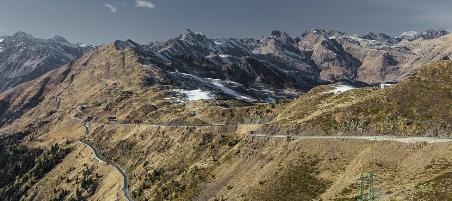
IDM Südtirol-Alto Adige/Daniel GeigerPanoramic tour over the pass
The Würzjoch is not only a paradise for hikers – motorcyclists, motorists and ambitious cyclists also appreciate the spectacular routes, the sweeping views and the comparatively peaceful atmosphere away from the major passes.
The approach from St. Martin in Thurn or via Afers in particular offers motorcyclists and motorists driving pleasure on a narrow but well-maintained road with many hairpin bends, moderate gradients and magnificent views of the Dolomites. The pass itself, with its huts and photo opportunities, invites you to stop for a short break or a longer rest. Those who enjoy sporting challenges can also reach the Würzjoch by bike or use the pass as a starting point for demanding mountain bike tours.

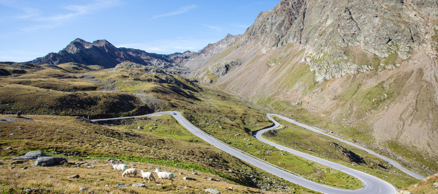
Numerous hikes start at the Würzjoch Pass and lead you into an impressive mountain world.
IDM Südtirol-Alto Adige/Harald WisthalerArriving by car and motorbike
The Würzjoch is somewhat remote, but still easy to reach. Well-maintained pass roads lead to the plateau from several valleys. There are three options by car:
- From the north via Lüsen: scenic, but winding. A good option if starting from the Brixen area.
- From the west through Afers or via Villnöss: narrow road in parts, busy in the high season.
- From the east via St. Martin in Thurn in Alta Badia: well-maintained, popular with motorcyclists.
It should be noted that the roads to the Würzjoch Pass are narrow in places and can be very busy during the high season. It is worth setting off early – both to avoid traffic and to find a parking space.
Parking at Würzjoch
Shortly before the pass summit on the Gadertal side, there is a paid car park, which fills up quickly during the high season. Additional parking spaces are available directly at the pass near Ütia de Börz. Parking on the roadside is not permitted.
Winter closure from December
Please note: Between May and November, the Würzjoch is accessible from all sides. In winter, however, access is only possible via St. Martin in Thurn to the top of the pass. Depending on the route, there are driving restrictions for buses and heavy vehicles.
Public transport

Many starting points for hikes in the Dolomites can be reached comfortably and environmentally friendly by public transport.
IDM Südtirol-Alto Adige/Manuel KotterstegerUsing public transport is recommended if you are planning hikes and want to avoid looking for parking spaces. The following bus connections can be used:
- From Villnöss: Connection only in summer via bus no. 339 from St. Peter, connection to Brixen via line 330.
- From Lüsen: Shuttle hiking bus in summer on certain days of the week.
- From St. Martin in Thurn: Line 464 from Pikolein in summer, in winter you need to change to line 339 in Untermoj.
All current timetables can be found at suedtirolmobil.info. With the Südtirol Guest Pass, you can use public transport in South Tyrol free of charge.

If you are interested in Ladin history and in the unique landscape of the Dolomites, you should absolutely visit the Museum Ladin at Ćiastel de Tor castle.
IDM Südtirol - Harald Wisthaler
Picturesque church in Villnöss in the Dolomites
Villnöss Tourismus GenossenschaftOther attractions in the area
- Museum Ladin Ciastel de Tor: Museum in St. Martin in Thurn on the history, language and culture of the Ladins, the third language group in South Tyrol.
- Mühlental/Mill Valley: In Campill, a hamlet of St. Martin in Thurn, a rustic walking trail leads past old, fully restored and functioning mills.
- Puez Geisler Nature Park: A unique nature reserve between Würzjoch and Grödnerjoch, a paradise for geologists and mountain lovers.
- St. Magdalena Church: Late Gothic church and popular photo motif in front of the striking mountain peaks of the Geisler group, at the end of the Villnöss Dolomite valley.
Frequently asked questions
Is the Würzjoch pass open all year round?
The route from Val Badia via St. Martin in Thurn is accessible all year round, while the route via Villnöss is only accessible from May to November.
When is the best time to visit the Würzjoch?
The best time for all outdoor activities is from June to September, when hiking trails, mountain huts, etc. are open and the weather is stable. The autumn months are a little quieter at the Würzjoch.
Can you reach the Würzjoch pass with a motorhome?
In principle, vehicles up to 12 metres in length are permitted to access the Würzjoch pass from all sides (except for buses, which are prohibited between Afers and the pass). However, some of the roads are narrow and traffic can be heavy.
Where can you park at the Würzjoch?
There are a limited number of paid parking spaces just before the Würzjoch (on the Gadertal side) and at the top of the pass. Parking at the roadside is prohibited.
What hikes are there for families at the Würzjoch?
Popular family hikes starting at the Würzjoch lead to the Pecol hut, the Munt de Fornella or the Maurerberg hut. The hikes around the Peitlerkofel and to the Göma hut are a little longer and more challenging.
Images

View of the Peitlerkofel near St. Martin in Thurn
Internet Consulting
The striking peak is located in the Puez-Geisler Nature Park and, at 2,875 metres, is the highest mountain in the Peitlerkofel group.
Internet Consulting
Fantastic mountain views at the Würzjoch pass at 2,000 m, between the Eisacktal/Lüsnertal and the Gadertal/Untermoital
Internet Consulting